Spences Bridge Gold Belt 50 kilometres west of Kelowna, B.C.
Size:
3200 ha
SUMMARY
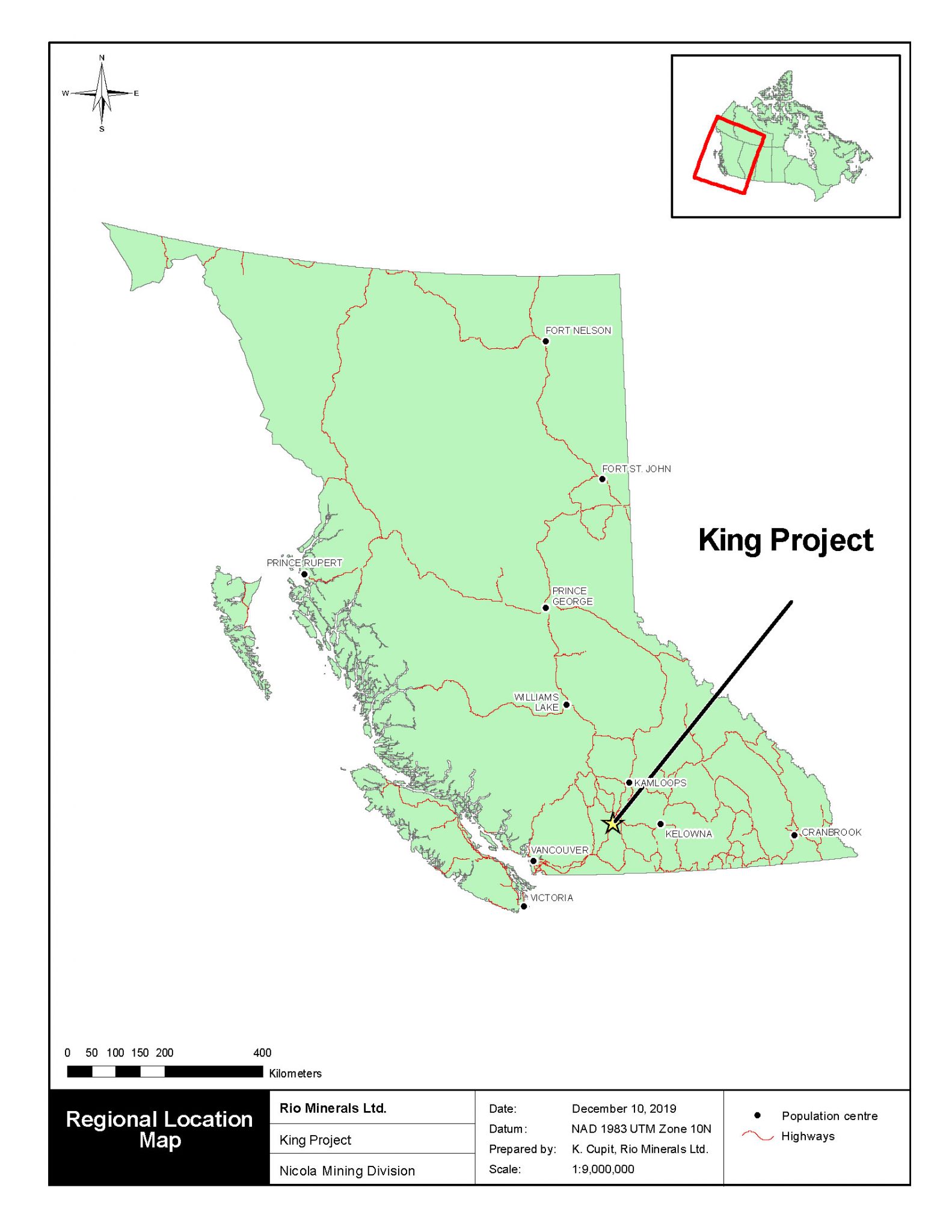
The King Property is located 50 kilometres west of Kelowna, B.C., and is comprised of eight MTO located mineral claims covering an area of 3206.61 hectares in the Nicola Mining Division of British Columbia. The claims are located on NTS map sheets 92H.089 and 92H.090. The claims are owned 100 percent by Barranco Gold Mining Corp. Current exploration is targeting gold-bearing structures in intrusive and volcanic rocks.
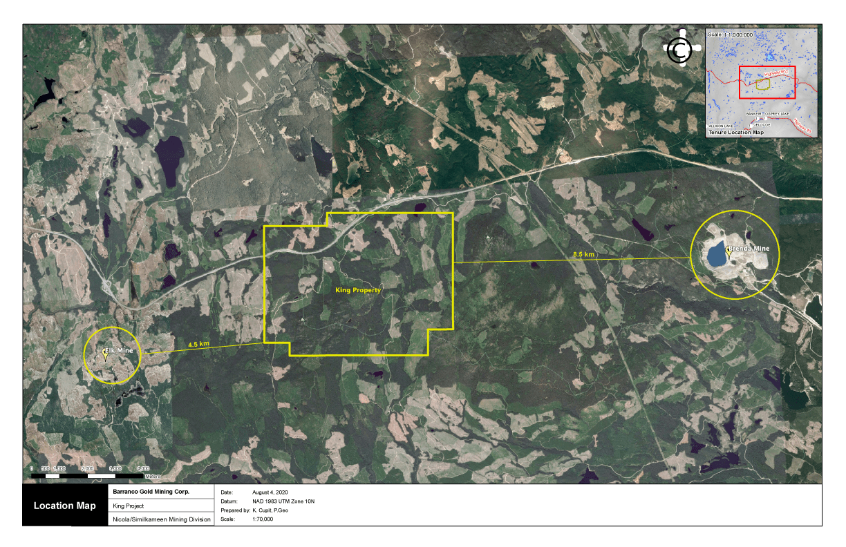
Highway 97C (Okanagan connector) transects the property providing excellent access. The physiography consists of treed hillsides, rolling plateau with lakes and swamps, and approximately 25 percent bedrock exposure.
Previous work during the 1960’s consisted of copper exploration in areas to the northeast and northwest portions of the property and recent gold exploration on the property as well as properties to the west and south.
The Siwash (Elk) Gold Deposit, currently owned by Almaden Minerals Ltd., is located four kilometres to the southwest, Siwash is a high-grade vein system which contains a drill indicated geological resource in excess of 200,000 ounces of gold with an average grade of 0.647 oz/ton Au.
The past-producing Brenda Mine is located 20 kilometers to the east of the King Property. The Brenda Mine operated from 1970 to 1990 and produced 278,000 tonnes of copper, 66,000 tonnes of molybdenum, 125 tonnes of silver, and 2 tonnes (64,302 oz) of gold.
The King property hosts a geological environment similar to that of the adjoining Siwash property. It straddles a narrow north-south neck of granodiorite batholith in contact on either side with andesitic to basaltic volcanics grading on the east to sedimentary rocks and minor limestone. An aeromagnetic high coincides with the intrusive body.
Mineralized gold-bearing quartz veins hosted by sheared, altered granite have been observed in rock cuts along the highway through the northern portion of the property. In the eastern portion of the property, siliceous volcanic rocks with disseminated arsenopyrite have returned high grade gold values.
A programme conducted by Cordilleran Engineering in 1991 consisting of wide-spaced (400m x 50m) grid soil sampling over approximately one-quarter of the property realized a total of 1074 samples. The samples were geochemically analyzed for gold, and fill-in sampling (50m x 50m) was conducted around those sites which yielded values greater than 20 ppb Au adding another 135 samples.
During this program, anomalous gold values were returned from the initial first pass sampling with the follow-up sampling programme confirming three of these anomalous returning additional values over distances of up to 150 meters and to a high of 91 ppb Au. Seventy-five percent of the property, underlain by a similar geological environment, remains to be sampled.
Gold-arsenopyrite mineralization is known to exist on the eastern portion of the claim area, and silver-rich quartz veins have been found in the western portions of the claims. Grab samples of quartz vein material with disseminated pyrite have returned values of up to 24100 ppb Au and 122.1 ppm Ag
This report outlines geochemical and geological data obtained as well as interpretation of the results. In order to continue to evaluate the economic potential of the King Property, a program consisting of geochemical soil sampling, silt sampling, prospecting, geological sampling and mapping as well as hand-trenching is recommended. The estimated budget for this program is $111,873.00. These recommendations are based on the writer’s interpretation of the data and are intended to serve as guidelines for future exploration and development of the King Property.
INTRODUCTION
This report was commissioned by Rio Minerals Ltd. (the “Company”), having offices at 615-800 West Pender Street, Vancouver, B.C. V6C 2V6 and prepared by Andris Kikauka, P. Geo.
In the preparation of this report, the author utilized both British Columbia and Federal Government of Canada geological maps, geological reports, and claim maps.
Information was also obtained from the following British Columbia Government websites:
as well as the mineral assessment work reports from the King Property area that have been historically filed by various companies.
The author reserves the right but will not be obliged; to revise the report and conclusions if additional information becomes known subsequent to the date of this report.
The information, opinions, and conclusions contained herein are based on:
Information available to the author at the time of preparation of this report
Assumptions, conditions, and qualifications as set forth in this report
Units and Measurements
Table 1: Definitions, Abbreviations, and Conversions
Units of Measure
Abbreviation
Units of Measure
Abbreviation
Above mean sea level
amsl
Micrometre (micron)
mm
Annum (year)
a
Miles per hour
mph
Billion years ago
Ga
Milligram
mg
Centimetre
cm
Milligrams per litre
mg/L
Cubic centimetre
cm3
Millilitre
mL
Cubic metre
m3
Millimetre
mm
Day
d
Million
M
Days per week
d/wk
Million tonnes
Mt
Days per year (annum)
d/a
Minute (plane angle)
M
Dead weight tonnes
DWT
Minute (time)
min
Degree
°
Month
mo
Degrees Celsius
°C
Ounce
oz
Degrees Fahrenheit
°F
Parts per billion
ppb
Diameter
ø
Parts per million
ppm
Gram
g
Percent
%
Grams per litre
g/L
Pound(s)
lb.
Grams per tonne
g/t
Power factor
pF
Greater than
>
Specific gravity
SG
Hectare (10,000 m2)
ha
Square centimetre
cm2
Gram
g
Square inch
in2
Grams per litre
g/L
Square kilometre
km2
Grams per tonne
g/t
Square metre
m2
Greater than
>
Thousand tonnes
kt
Kilo (thousand)
k
Tonne (1,000kg)
t
Kilogram
kg
Tonnes per day
t/d
Kilograms per cubic metre
kg/m3
Tonnes per hour
t/h
Kilograms per hour
kg/h
Tonnes per year
t/a
Kilometre
km
Total dissolved solids
TDS
Kilometres per hour
km/h
Total suspended solids
TSS
Less than
<
Week
wk
Litre
L
Weight/weight
w/w
Litres per minute
L/m
Wet metric tonne
wmt
Metre
King
Yard
yd.
Metres above sea level
masl
Year (annum)
a
Metres per minute
m/min
Year
yr.
Metres per second
m/s
Metric ton (tonne)
t
PROPERTY DESCRIPTION AND LOCATION
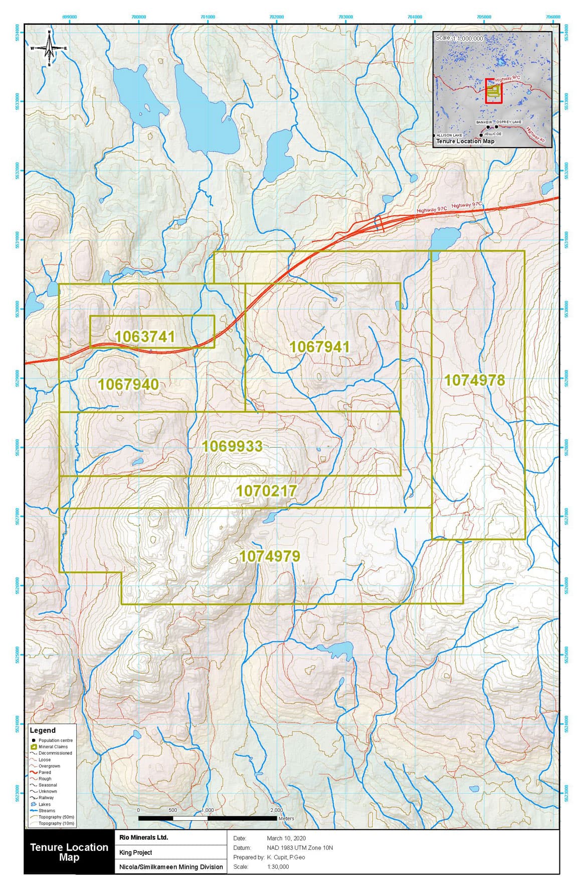
The King Property consists of seven non-surveyed mineral claims totalling 3206.61 hectares located on NTS map sheets 092H.089 and 92H.090 centered at Latitude 49° 55” Longitude 120° 51’. The claims are located within the Nicola Mining Division, of British Columbia. The Mineral claims are shown on Figure 2, and the claim details are illustrated in the following table:
Table 2: Property Tenure Information
Title Number
Claim Name
Owner
Title Type
Good To Date
Area (ha)
1063741
KING
118700 (100%)
Mineral
2021/DEC/31
83.26
1067940
KING 2
118700 (100%)
Mineral
2021/DEC/31
416.36
1067941
KING 3
118700 (100%)
Mineral
2021/DEC/31
416.36
1069933
KING – 4
118700 (100%)
Mineral
2021/DEC/31
458.11
1070217
KING – 5
118700 (100%)
Mineral
2021/DEC/31
520.52
1074978
KING – 6
118700 (100%)
Mineral
2021/DEC/31
562.14
1074979
KING – 7
118700 (100%)
Mineral
2021/DEC/31
749.86
BC Mineral Titles Online indicates that Barranco Gold Mining Corp. is the current registered owner of the tenures listed above.
The author undertook a search of the tenure data on the government of British Columbia Mineral Titles Online (MTO) website which confirms the geospatial locations of the claim boundaries and the property ownership as of April 3, 2020.
In British Columbia, the owner of a mineral claim acquires the right to the minerals that were available at the time of claim location and as defined in the Mineral Tenure Act of British Columbia. Surface rights and placer rights are not included. Claims are valid for one year and the anniversary date is the annual occurrence of the date of record (the staking completion date of the claim).
To maintain a claim in good standing the claim holder must, on or before the anniversary date of the claim, pay the prescribed recording fee and either: (a) record the exploration and development work carried out on that claim during the current anniversary year; or (b) pay cash in lieu of work. The amount of work required in years one and two is $5 per hectare per year, years 3 and 4 $10 per hectare, years 5 and 6 $15 per hectare, and $20 per hectare for each subsequent year.
Only work and associated costs for the current anniversary year of the mineral claim may be applied toward that claim unit. If the value of work performed in any year exceeds the required minimum, the value of the excess work can be applied, in full year multiples, to cover work requirements for that claim for additional years (subject to the regulations). A report detailing work done and expenditures must be filed with, and approved by, the B.C. Ministry of Energy and Mines.
Figure 1: Regional Location Map
Regional Location Map (Satellite)
Figure 2: Property Tenure Map
ACCESSIBILITY, CLIMATE, PHYSIOGRAPHY, LOCAL RESOURCES, AND INFRASTRUCTURE
The King property is located 50 kilometres west of Kelowna in south-central British Columbia. It is centered on latitude 49 degrees 55′ north and longitude 120 51’ degrees west within NTS Map areas 92H.089 and 92H.090. Access to the property is via Highway 97C (Okanagan connector) 40 km west from Westbank. The highway transects the claims from northeast to southwest.
Access to the property is provided by secondary roads extending from the old Quilchena power line road via Sunset Main to Paradise Lake and to Reservoir Lake as well as numerous secondary logging roads.
The claims enclose an area of a broad uplands plateau with limited relief. Elevations range from 1550m to 1850m above sea level. Roughly 10 percent of the area is covered by small lakes or marsh. Bedrock exposure is limited, being confined to highway rock cuts and to the southeast portion of the claims were some steeper slopes are present. Northerly-flowing, small to medium size streams meander across the property but most have not eroded deeply enough to expose bedrock.
Forest cover comprises pine, fir, spruce, and balsam. Clear cut logging has been undertaken on portions of the claims. Annual temperatures range from -20 degrees to 30 degrees centigrade and precipitation is low to moderate. The area is basically snow-free from mid-June through November.
HISTORY
Copper exploration which consisted of soil sampling, airborne EM/Mag, and I.P. surveys was undertaken from 1966 to 1968. Minor copper showings were discovered in volcanic and intrusive host rocks.
From 1986 to the present, high grade gold vein systems have been the subject of exploration by Fairfield Minerals Ltd. and Almaden Minerals Ltd. on the adjoining Elk property located four kilometres to the southwest of the King property. Geochemical and geophysical surveys, trenching, and diamond drilling at Elk have revealed several gold-bearing structures, one of which contains a drill indicated geological resource in excess of 200,000 ounces of gold with an average grade of 0.647 oz/ton Au.
Reconnaissance prospecting and sampling in the King property area was carried out by Cordilleran Engineering Ltd. from 1986 through 1991. Highly anomalous gold values as well as high values in silver, copper, lead, zinc, and arsenic were returned from a number of stream sediment, soil, and rock samples.
GEOLOGICAL SETTING AND MINERALIZATION
Regional Geology
After JWH Mongery, et al, 1989
Regional geology in the area of the King property is illustrated on the northeast part of GSC map 41-1989, Hope, mapped by J.W.H..Mongery:
The claims straddle a narrow, north-south neck of the Pennask batholith approximately 5 km wide and in contact on the east and west with volcanic and sedimentary rocks of the Nicola Group. The batholith comprises white to grey, medium to fine grained granodiorite of Late Triassic to Early Jurassic age. To the south it is in contact with Late Jurassic coarse-grained pinkish granite to granodiorite. Nicola Group rocks consist of Late Triassic andesite to basalt flows and pyroclastics changing facies to the east to a sequence of interbedded argillite, sandstone, tuff, and minor limestone.
GSC Aeromagnetic Map sheet 92H/16 (No. 8528G) indicates a magnetic high of 58,500 gammas, approximately 2 km long, trending northeasterly across the center of the property in the area currently mapped as granodiorite.
Property Geology
After Rowe, et al, 1989
Rock cut exposures along the highway on the south-central claims consist predominantly of coarse-grained pinkish granite. Shear zones within the granite are often accompanied by argillic to phyllic alteration over widths of up to several meters with local narrow quartz veins emplaced in the shears. Iron and manganese oxides are common in the alteration zones. Grab samples of quartz vein material with disseminated pyrite have returned values of up to 24100 ppb Au and 122.1 ppm Ag (Rowe, J. 1991. AR 21922). Andesite dykes up to 0.5m wide of probable Tertiary age have been observed cutting granite near mineralized quartz veins. Similar dykes are spatially associated with gold-bearing quartz veins on the nearby Elk property.
A grab sample of siliceous volcanic rock with disseminated to semi-massive arsenopyrite taken from the eastern portion of the property returned 1830 ppb Au and 30530 ppm As. Samples taken in the middle of the claim group of quartz veins up to 6 cm wide in sheared, altered volcanic rock returned values up to 0.071 oz/ton Au and 30.5 oz/ton Ag with minor copper, lead, and zinc. A grab sample taken approximately 1 kilometer south of the road of similarly mineralized quartz vein material gave values of 24100 ppb Au (0.70 oz/ton) and 85.6 ppm Ag (2.50 oz/ton. Rowe, J. 1991. AR 21922).
Shears and vein structures measured on the property have predominantly east to northeast strikes and moderate to steep southerly dips. It has been observed that most of the gold-bearing structures in the region have similar trends.
The geological setting is similar to that of the adjoining Siwash (Elk) property where, 4 km to the southwest, a gold-bearing quartz vein system cutting granitic and volcanic rocks is being explored. In addition, the Brenda copper-molybdenum deposit located 20km east of the King property is hosted by similar geological units.
Figure 3: Regional Geology Map
Minfile Showings Located on the Property
The King showing (092HNE297): occurs along a logging roadcut, 1.5 kilometres southeast of the Coquihalla Highway (Okanagan Connector), 4.0 kilometres northeast of Culmination Point and 3.5 kilometres west-southwest of the summit of Pennask Mountain.
A quartz vein, 1 centimetre wide, cuts bleached, pyritic andesitic ash tuff of the Upper Triassic Whistle Creek Formation (Nicola Group). A sample of selected chips analysed 0.68 gram per tonne gold (Assessment Report 21922, page 9, Table 2, sample L89-R1D). The showing was sampled by Kingsvale Resources Inc. in 1991.
The King 6 showing (092HNE298): occurs along the north side of the Coquihalla Highway (Okanagan Connector), 2.6 kilometres north-northwest of Culmination Point and 7.4 kilometres west of the summit of Pennask Mountain.
A drusy quartz vein, 10 centimetres wide, cuts coarse-grained, feldspar megacrystic granite of the Middle Jurassic Osprey Lake batholith. The vein is mineralized with scattered blebs of chalcopyrite. A selected sample analysed 0.41 grams per tonne gold and 7.8 grams per tonne silver (Assessment Report 21922, page 9, Table 2, sample Q1b-R3).
The King 8 showing (092HNE299): is on the north side of the Coquihalla Highway (Okanagan Connector), 2.7 kilometres north-northeast of Culmination Point and 6.0 kilometres west of the summit of Pennask Mountain.
A shear zone, 70 centimetres wide, cuts coarse-grained, phyllic, sericitic-altered granite of the Middle Jurassic Osprey Lake batholith, near an andesitic dike. The showing is approximately 100 meters south of the contact with andesitic ash and lapilli tuff of the Upper Triassic Whistle Creek Formation (Nicola Group). A pyritic quartz-calcite vein/breccia is associated with the shear zone. A series of selected chips from the vein yielded 0.44 grams per tonne gold and 10.6 grams per tonne silver (Assessment Report 21922, page 9, Table 2, sample Q17-R2A).
Figure 4: Minfile Location Map
EXPLORATION
PREVIOUS EXPLORATION
A total of 1209 soil samples were collected from the King property in 1991. Wide spaced (400m x 50m) initial grid sampling yielded 1074 samples. These lines were established in two areas of the property covering the contact zones of the batholith and areas of known gold mineralization which were believed to have the best potential for the discovery of gold deposits.
East-west claim lines served as baselines. They were measured with a hip chain, marked with pink flagging and at certain stations, marked with grid-numbered, waterproof Tyvek tags plus pink and blue flagging. North-south soil lines were established using hip chain and compass, and soil stations at 50m intervals were similarly identified with tags plus orange and blue flagging. Subsequent fill-in line locations were determined from existing initial grid stations.
Samples were collected from the „B“ horizon with mattocks and placed in Kraft paper bags marked with the appropriate grid coordinates. The samples were sent to Acme Analytical Laboratories Ltd. in Vancouver where they were dried, sieved, and the -80 mesh fraction used for gold analysis. Each sample was tested for gold by atomic absorption following aqua regia digestion and MIBK extraction from a 10-gram sample (Rowe, J. 1991. AR 21922).
The wide-spaced grid sampling of selected portions of the property was adopted to economically explore the largest extent reasonable, at the risk of missing narrow, high grade gold veins which may lie between 400 meter-spaced lines.
The initial grid sampling returned nine values greater than 20 ppb Au to a high of 130 ppb, dispersed widely across the property. Fill-in sampling around these sites confirmed the existence of anomalous gold in three of the areas by yielding additional values of 94 ppb Au (Rowe, J. 1991. AR 21922).
Wide-spaced soil sampling, with limited follow-up over approximately one-quarter of the King property has indicated three zones of anomalous gold.
Table 3: Historic Rock Sample Descriptions:
Sample ID
Locality
Sample Type
Description
Sample Width (cm)
Au ppb
Ag ppm
Q16-R3
KING
Grab
Broken sub-crop, 10cm drusy qtz vein with scattered blebs of chalco
10
410
7.8
Q17-R2A
KING
Chip
In-situe pyritic qtz-calcite veins. Bx assoc w 70cm wide shear zone in phyllic altered granite near andesite dyke
grab
440
10.6
Q20-R2
KING
Float
Selected grabs from several qtz veins, cobbles up to 10cm wide. Drusy, with minor pyrite and chalcopyrite
grab
820
–
Q20-R6
KING
Float
Several small, angular qtz vein fragments – in part hematitic w/fe and minor oxides
grab
720
122.1
Q20-R6
KING
Chip
Selected chips from in-situe 1 cm qtz vein cutting bleached, silicic, pyritic andesite
grab
680
–
L89-R14
KING
Float
Selected grab of qtz flooded granite w/clots of py, cpy, qn, sp
Rock sample locations were marked in the field with pink and blue flagging tape and their respective locations along with sample descriptions were recorded. The samples were then placed in marked poly bags, zap-strapped, and delivered to Acme Laboratories located Vancouver, BC for analysis.
Figure 5: Rock Sample Location Map
DEPOSIT TYPES
An epithermal gold deposit is one in which the gold mineralization occurs within 1 to 2 km of surface and is deposited from hot fluids. The fluids are estimated to range in temperature from less than 100°C to about 300°C and, during the formation of a deposit, can appear at the surface as hot springs. The deposits are most often formed in areas of active volcanism around the margins of continents (Norcross 1997).
Epithermal gold mineralization can be formed from two types of chemically distinct fluids — „low sulphidation“ (LS) fluids, which are reduced and have a near-neutral pH (the measure of the concentration of hydrogen ions), and „high sulphidation“ (HS) fluids, which are more oxidized and acidic. LS fluids are a mixture of rainwater that has percolated into the subsurface and magmatic water (derived from a molten rock source deeper in the earth) that has risen toward the surface. In both LS and HS models, fluids travel toward the surface via fractures in the rock, and mineralization often occurs within these conduits. LS fluids usually form large cavity-filling veins, or a series of finer veins, called stockworks, that host the gold. The hotter, more acidic HS fluids penetrate farther into the host rock, creating mineralization that may include veins, but which is mostly scattered throughout the rock.
Low sulphidation deposits can also contain economic quantities of silver and minor amounts of lead, zinc, and copper, whereas high sulphidation systems often produce economic quantities of copper. Geochemical exploration for these deposits can result in different chemical anomalies, depending on the type of mineralization involved. Low sulphidation systems tend to be higher in zinc and lead, and lower in copper, with a high silver-to-gold ratio. high sulphidation systems can be higher in arsenic and copper with a lower silver-to-gold ratio (Norcross 1997).
INTERPRETATION AND CONCLUSIONS
The King property is located in the Spences Bridge Gold Belt of British Columbia, Canada. The Spences Bridge Gold Belt is an underexplored, emerging 200-kilometre-long-by-30-kilometre-wide low-sulphidation epithermal gold belt.
Interpreted to be a failed cretaceous rift basin, it is believed the belt is prospective for Fruta del Norte style high-grade epithermal mineralization. It is close to major transportation routes and infrastructure allowing for cost-effective exploration. The SBGB is a northwest-trending belt of intermediate to felsic volcanic rocks dominated by the Cretaceous Spences Bridge Group.
The King property is located within the SBGB and hosts a geological environment similar to that of the adjoining Elk (Siwash) property. The Siwash Gold Deposit, currently owned by Almaden Minerals Ltd., is located four kilometres to the southwest. Siwash is a high-grade vein system which contains a drill indicated geological resource in excess of 200,000 ounces of gold with an average grade of 0.647 oz/ton Au.
The past-producing Brenda Mine is located 20 kilometers to the east of the King Property. The Brenda Mine operated from 1970 to 1990 and produced 278,000 tonnes of copper, 66,000 tonnes of molybdenum, 125 tonnes of silver, and 2 tonnes (64,302 oz) of gold.
Soil sampling on the King Property returned high gold in soil values over distances of up to 150 meters. Six rock samples taken on the property by Cordilleran Engineering returned up to 24.1 grams per gold and 122.1 grams per tonne silver.
Gold-arsenopyrite mineralization is known to exist on the eastern portion of the claim area, and silver-rich quartz veins have been found in the western portions of the claims.
The discovery of high-grade mineralization, excellent infrastructure, and location in the Spences Bridge Gold Belt provides a compelling target for gold/silver exploration.
SIGN UP FOR NEWS
Signup for our newsletter to get notified about our news updates.